Narromine Levee Have your say
-
Narromine Levee Feasibility Study
Narromine residents and businesses are being invited to provide feedback on the Narromine Levee Feasibility Study that is currently underway.
The Narromine Levee Feasibility Study is being undertaken by consultancy firm Stantec to determine a detailed design and cost estimation of a levee extension for the town of Narromine.
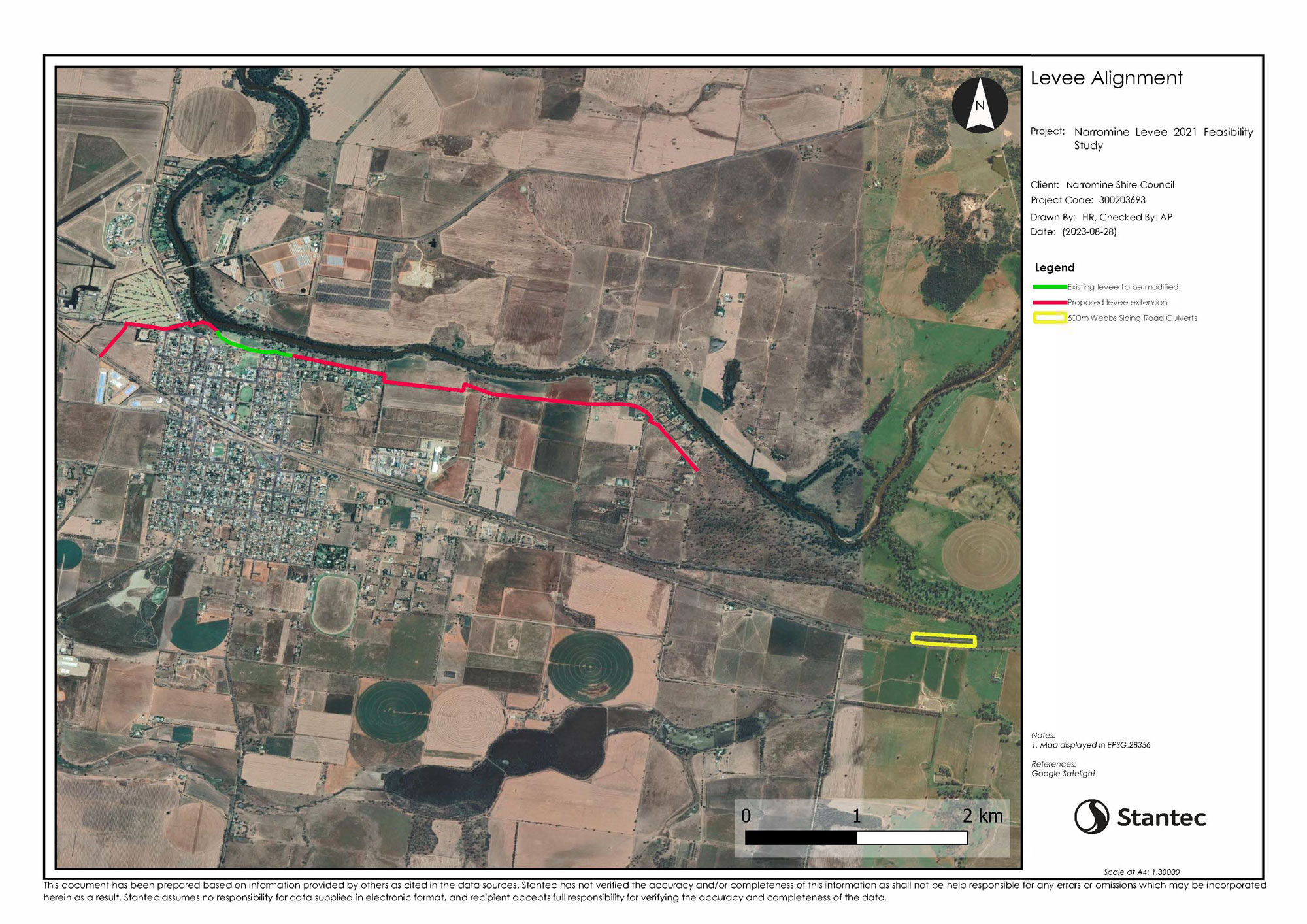
The proposed levee extension project
- The existing 800-metre Narromine town levee alignment that is contained within Rotary Park is proposed to be raised to be above the 1 in 100-year flood level (1% Annual Exceedance Probability or AEP) plus an assigned freeboard (which is an additional levee height to provide a factor of safety to ensure the levee does not overtop);
- An extension of the existing levee (approx. 7,500 metres) from both ends of the levee:
Heading north-west along Warren Road, and behind the rear of the Peppercorn Motor Inn then west along the Mitchell Highway and then south along the rear of residences of Sixth Avenue; and east along the northern side of Crossley Drive, continuing east to River Drive. - These new lengths of levee will also be raised to be above the 1 in 100-year flood level plus freeboard.
- Associated with the levee extension will be the construction of railway culverts placed along 500 metres of the existing Main Western Line at Webbs Siding Road. (eastern side of Narromine) that will return water into Backwater Cowal that flows south of Narromine township.
The proposed town levee in Narromine could vary in height from 1 to 2 metres above the ground level (subject to further survey and confirmation), along sections, including the riverbank slope. The proposed levee alignment generally has access along or adjacent to its internal face for inspection and /or maintenance purposes.
Tasks that will be involved within this study include
- Phase A – C:
Initial investigations phase is proposed to be completed by October 2023. These initial investigation works will include the following:- A comprehensive data collection and review;
- Consultation with community and stakeholders;
- Topographical survey of the levee alignment;
- Review of existing flood studies to determine an appropriate 1% ARI flood levels and freeboard requirements;
- Contaminated site assessment, biodiversity and environmental initial assessments;
- Conduct geotechnical investigations and geotechnical investigations of the proposed levee and assess the associated riverbank stability at critical sections of the river adjacent to the levee.
- Phase D:
Concept Design phase is proposed to be completed by February 2024. This phase includes the preparation of a concept design report with the analysis of applicable flood levels, adopted level of protection for the community and the investigated levee alignment options with relevant freeboards and other design criteria along with a preliminary environmental planning overview; - Phase E:
Environmental assessment studies, such as Review of Environmental Factors, or Environmental Impact Statement, as required. These environmental assessments shall be conducted throughout the concept and detailed design phases; and - Phase F:
Detailed design and documentation including cost estimation proposed to be completed by May 2024.
Make an online submission below or provide a written submission to: The General Manager, PO Box 115, Narromine, NSW 2821 these can be:
- Mailed to PO Box 115, Narromine, NSW 2821
- Faxed to 02 6889 9998
- Emailed to mail@narromine.nsw.gov.au
One-on-one meetings will be scheduled to be held after the completion of Phases D and F
Have questions or want to learn more about the project?
Drop in to talk to us:
Narromine Shire Council
Customer Service and Payments Centre
118 Dandaloo Street
NARROMINE NSW 2821
Phone: 02 6889 9999
Fax: 02 6889 9998
Email: mail@narromine.nsw.gov.au -
Narromine Levee Timeline
The timeline on the Narromine Levee Bank is as per below.
2009 Floodplain Risk Management Plan and Study finalised. Recommendation from this to investigate feasibility of augmenting Narromine Levee 2010 Flood in December. Necessary to review the 1% height 2011 Flood Levee Bank Committee formed 2013 Community Consultation 2017 Peer review 2018 Where to from now?
- Decide on an alignment (completed)
- Community Consultation (completed)
- Receipt of submission
- Finalise the feasibility study
- Final feasibility study presented to Council for final determination
2020 Review of the Narromine Floodplain Risk Management Study and Plan
Narromine Shire Council engaged consultants to undertake a review of the Narromine Floodplain Risk Management Study and Plan which was prepared for the township in 2009.The purpose of the review was to assist Council in refining strategic plans for mitigating and managing the effects of existing flood risk (associated with existing development on flood prone land), future flood risk (associated with any new development on flood prone land) and continuing flood risk (the risk remaining in both existing and future development areas after floodplain risk management measures are implemented).
2023 A Feasibility Study is underway. It is anticipated that community consultation and engagement is to commence in August 2023.
-
Review of the Narromine Floodplain Risk Management Plan
Narromine Shire Council engaged consultants to undertake a review of the Narromine Floodplain Risk Management Study and Plan which was prepared for the township in 2009. The purpose of the review was to assist Council in refining strategic plans for mitigating and managing the effects of existing flood risk (associated with existing development on flood prone land), future flood risk (associated with any new development on flood prone land) and continuing flood risk (the risk remaining in both existing and future development areas after floodplain risk management measures are implemented).
The review was jointly funded by Council and the NSW Department of Planning, Industry and Environment and aimed to build community resilience towards flooding through informing better planning of development, emergency management and community awareness. Council has established a Floodplain Risk Management Committee which is comprised of relevant council members, state government agencies and community representatives.
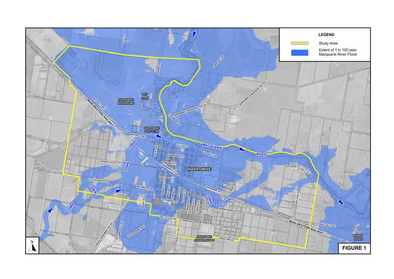
The review utilised the results of the Narromine River Bank Levee Feasibility Study which was completed in 2013. Figure 1 attached shows the indicative extent of the 1 in 100 year flood on the Macquarie River at Narromine under present day conditions as defined by this study.
 A brief summary of the floodplain risk management measures which form the Narromine Floodplain Risk Management Plan (2009), including their estimated cost is provided below.
 Floodplain Management Measures Forming the Narromine Floodplain Risk Management Plan (2009)
Option Estimated Cost Priority Assigned to Implementation of Measure Status of Measure PM1 – Implement the recommended development controls based on draftFlood Policy for Narromine. Council staff’s Cost High Implemented RM1 – Ensure flood data in this Floodplain Risk Management Study and draft Plan is available to NSW SES for inclusion in flood emergency response. Council and NSW SES Costs High Implemented RM2 – Implement flood awareness and education program for residents and owners of commercial and industrial developments. NSW SES and Property/Business Owner Costs High Implemented FM1 – Feasibility Study of river bank levee.(1,2) $80,000(1) High Completed FM2 – Preparation of detailed design and construction of levee (dependent on the results of the above study). $1.6 Million(3) Medium Underway FM3 – Feasibility Study of upgrading the hydraulic capacity of culverts beneath the Parkes Narromine Railway.(4) $50,000(3) Medium Yet to be commenced FM4 – Prepare detailed design and construct culvert works (scheme is dependent on the results of the above study and whether river bank levee scheme is implemented. The river levee would reduce ponding upstream of the railway and possibly reduce the need for improved culverts).(4) $0.8 Million(3) Medium Yet to be commenced Total Cost of Implementing Flood Mitigation Measures FM1, FM2, FM3 and FM4 $2.53 Million(3) 1. FM1 was completed in 2013. The results of the study are presented in Narromine River Bank Levee Feasibility Study (2013)
2. Scope of floodplain risk management measure refined as part of Narromine River Bank Levee Feasibility Study (2013) and the Narromine Town Levee Concept Design (2016).Figure 1 shows the currently proposed alignment of the river bank levee.
3. Following the adoption of the revised Plan, Narromine Shire Council can seek funding from the NSW State Government under its Floodplain Management Program to cover the majority of the cost of implementing the recommended set of measures.
4. Refer Figure 1 for location of the proposed upgraded culverts.
An electronic copy of the Narromine Floodplain Risk Management Study and Plan (2021) can be found below.
Narromine Floodplain, Risk management study and Plan 2021 Section 1.pdf
Narromine Floodplain, Risk management study and Plan 2021 Section 2.pdf
An electronic copy of the Narromine Floodplain Risk Management Study and Plan (2009) and Narromine River Bank Levee Feasibility Study (2013) can be found below.
Narromine Floodplain, Risk management study and Plan 2009 section 1.pdf
Narromine Floodplain, Risk management study and Plan 2009 section 2.pdf
Narromine Floodplain, Risk management study and Plan 2009 section 3.pdf
158^D3 Lyall 20131200 Narromine River Bank Levee Feasibility Study Volume 1 - Final Report.pdf
158^D3 Lyall 20131200 Narromine River Bank Levee Feasibility Study Volume 2 - Figures.pdf